When it comes to the breathtaking images of galaxies, stars, and planets that we see in the media, few people stop to think about the extensive process of space image processing that goes into creating those stunning visuals. From the moment a spacecraft captures an image, to the time it appears on our screens, the data undergoes a series of complex transformations, involving corrections, enhancements, and interpretations. This process is crucial not only for making the images visually appealing but also for extracting valuable scientific information. In this article, we will delve into the fascinating world of space image processing, exploring its history, techniques, and significance.
Space image processing is a multidisciplinary field that combines astrophysics, computer science, and engineering to convert raw data from space missions into meaningful and aesthetically pleasing images. The process involves a range of techniques, from basic corrections for instrumental artifacts and radiation damage, to advanced methods like deconvolution and spectral analysis. As we will see, space image processing has become an essential tool for space agencies, researchers, and scientists, enabling them to study the universe in unprecedented detail.
The history of space image processing dates back to the early days of space exploration, when the first spacecraft were launched to capture images of the Earth, Moon, and other celestial bodies. The initial images were often blurry, distorted, and lacking in detail, due to the limited capabilities of the onboard cameras and the harsh conditions of space. However, as technology improved, so did the quality of the images, and with it, the need for sophisticated space image processing techniques. The Voyager missions, launched in 1977, marked a significant milestone in this regard, as they returned a wealth of images from the outer Solar System, which required careful processing to reveal their full scientific value.
Early Challenges and Innovations
In the early days of space exploration, one of the major challenges was the limited bandwidth available for transmitting image data back to Earth. This meant that images had to be highly compressed, which often resulted in a loss of detail and fidelity. To overcome this, scientists developed innovative techniques like data compression, error correction, and image reconstruction. These early innovations laid the foundation for the sophisticated space image processing methods used today, which can handle vast amounts of data and produce images of breathtaking clarity and resolution.
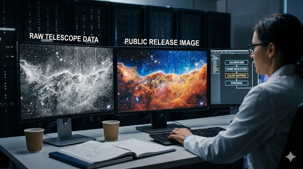
One of the first steps in space image processing is to correct for instrumental artifacts and errors. This includes removing distortions caused by the camera’s optics, as well as accounting for radiation damage, thermal fluctuations, and other environmental factors that can affect the image quality. For example, the Hubble Space Telescope’s cameras are sensitive to charged particles, which can cause bright streaks and other artifacts in the images. By applying sophisticated correction algorithms, scientists can remove these artifacts and restore the original image quality.
- Camera optics corrections: removing distortions and aberrations caused by the camera’s lens and mirror systems
- Radiation correction: accounting for the effects of cosmic rays and other high-energy particles on the image sensor
- Thermal correction: compensating for temperature fluctuations that can cause changes in the camera’s focal length and other parameters
Once the instrumental corrections have been applied, the next step is to enhance the image quality using a range of techniques. This can include contrast stretching, noise reduction, and sharpening, as well as more advanced methods like deconvolution and spectral analysis. Deconvolution, for example, involves using complex algorithms to reverse the effects of blurring and distortion, allowing scientists to recover detailed information about the object being imaged. Spectral analysis, on the other hand, involves breaking down the image into its component colors and analyzing the resulting spectrum to extract information about the object’s composition and properties.
- Contrast stretching: adjusting the brightness and contrast of the image to reveal details in both bright and dark areas
- Noise reduction: removing random fluctuations and other sources of noise that can degrade the image quality
- Sharpening: enhancing the image resolution and clarity using techniques like unsharp masking and deconvolution
Color correction and calibration are critical steps in space image processing, as they allow scientists to accurately represent the colors and spectral properties of the objects being imaged. This involves accounting for the effects of atmospheric scattering, instrument response, and other factors that can affect the color balance and fidelity of the image. For example, images of the Earth’s surface must be corrected for the effects of atmospheric scattering, which can cause the colors to appear distorted and unnatural. By applying sophisticated color correction algorithms, scientists can restore the natural colors and spectral properties of the image, revealing valuable information about the object’s composition and properties.
- Atmospheric correction: accounting for the effects of atmospheric scattering and absorption on the image
- Instrument response: calibrating the instrument’s spectral response to ensure accurate color representation
- Color balancing: adjusting the color balance and fidelity of the image to match the object’s natural appearance
Image mosaicking and panoramas are powerful tools in space image processing, allowing scientists to combine multiple images into a single, seamless mosaic. This can be used to create wide-field images of the sky, as well as detailed panoramas of planetary surfaces and other celestial bodies. For example, the Curiosity rover’s cameras can capture stunning panoramas of the Martian landscape, which are then stitched together using sophisticated algorithms to create a seamless and immersive image. By analyzing these mosaics and panoramas, scientists can gain valuable insights into the geology, composition, and evolution of the objects being imaged.
- Image registration: aligning and registering multiple images to create a seamless mosaic
- Image blending: combining the images using techniques like gradient blending and feathering
- Panorama stitching: creating detailed panoramas of planetary surfaces and other celestial bodies
Finally, advanced space image processing techniques like machine learning, deep learning, and artificial intelligence are being increasingly used to analyze and interpret space images. These techniques can be used to detect patterns, classify objects, and extract valuable information from the images, often with greater accuracy and efficiency than traditional methods. For example, machine learning algorithms can be trained to recognize specific features and patterns in images of the Martian surface, allowing scientists to identify potential landing sites and areas of interest. By leveraging these advanced techniques, scientists can unlock new insights and discoveries from the vast archives of space images, and push the boundaries of our understanding of the universe.
- Machine learning: using algorithms like convolutional neural networks to detect patterns and classify objects
- Deep learning: applying techniques like deep neural networks to analyze and interpret complex images
- Artificial intelligence: using AI-powered tools to automate the image analysis and interpretation process
While space image processing has revolutionized our understanding of the universe, it is not without its limitations and challenges. One of the main counter-arguments is that the processing techniques can sometimes introduce artifacts and biases, which can affect the accuracy and reliability of the results. Additionally, the vast amounts of data generated by space missions can be overwhelming, requiring significant computational resources and expertise to process and analyze. Furthermore, the use of advanced techniques like machine learning and deep learning can be problematic, as they often require large amounts of training data and can be sensitive to errors and biases in the data.
Conclusion
In conclusion, space image processing is a critical component of space exploration, allowing scientists to extract valuable information and insights from the vast archives of space images. From instrumental corrections and image enhancement, to color correction and calibration, image mosaicking and panoramas, and advanced techniques like machine learning and deep learning, the process of space image processing is complex, multifaceted, and essential for advancing our understanding of the universe. As we continue to push the boundaries of space exploration and discovery, the importance of space image processing will only continue to grow, enabling us to uncover new secrets and mysteries of the cosmos.