The Ice Wall — What Early Explorers Really Saw at Earth’s Southern Frontier
admin
Author
Long before NASA, before satellites, before the Antarctic Treaty sealed the southern frontier behind diplomatic iron gates, the world’s earliest explorers recorded something extraordinary — a feature so massive, so imposing, and so mysterious that it contradicted every map of their age. They found not a continent, not a landmass, but a towering wall of ice stretching endlessly across the horizon.
Their journals, though rarely taught today, form one of the most compelling bodies of firsthand evidence for a hidden boundary at Earth’s southern edge.
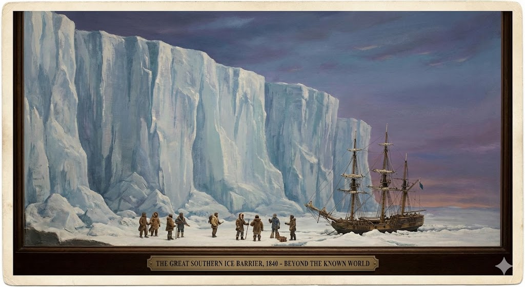
The story begins in the late 1700s and early 1800s, when European expeditions first sailed into the frigid waters of the far south. The oceans grew turbulent. Winds intensified. Temperatures dropped sharply. Yet it wasn’t a continent that greeted them — it was a barrier. A ring. A wall.
Captain James Cook, often celebrated as one of history’s greatest navigators, encountered it repeatedly during his three-year circumnavigation of the southern oceans. His logs describe “immense and stupendous ice cliffs” rising out of the water like the ramparts of a frozen fortress. Cook sailed more than 60,000 miles around the southern latitudes — the longest such voyage of his time — and not once did he break through to find a continent. Instead, he found ice stretching in all directions, an unbroken barrier blocking further exploration.
His words are striking not only for their vividness but for their consistency. Cook noted walls 150 feet high, spanning as far as the eye could see, with no land beyond. He described the ice as a boundary “not to be penetrated,” and warned future sailors that nature itself forbade passage.
Cook’s account was so unsettling that for decades afterward, other explorers struggled to reconcile it with the world maps of their time. If Antarctica were truly a normal landmass, why did no one find it? Why did Cook see walls instead of coastlines? Why did every attempt end in the same icy barrier?
In the mid-1800s, the American explorer Charles Wilkes reported similarly daunting formations that looked less like natural coastlines and more like the edge of an impenetrable shelf. He charted fragments of ice cliffs but admitted that land was uncertain — perhaps nonexistent. Many of his sightings were later dismissed or quietly reinterpreted, but his journals remain.
Then came James Clark Ross, whose name now marks the “Ross Ice Shelf.” His expedition, often portrayed as a conventional scientific venture, contains descriptions far more dramatic in context. Ross encountered towering vertical walls rising sheer from the sea — the very definition of a barrier. The Ross Ice Shelf was not a gentle slope of snow-covered land. It was a colossal barrier, hundreds of feet high, stretching across vast distances. Ross described it as a “great ice cliff,” too steep and too hostile to climb.
He never set foot on it.
Nor did his men.
Nor did any expedition until decades later — and even then, only in carefully controlled circumstances.
The question few ask is: Why do these cliffs exist? Why does a ring of vertical ice surround the southernmost waters like a fortress wall? And why did explorers repeatedly encounter these features instead of accessible shores?
The official narrative frames them as the edges of ice shelves attached to a continent. But the early journals paint a different picture — one of a boundary encircling the world’s southern frontier. A barrier so consistent, so uniform, that explorers who went too far simply turned back, defeated by nature’s frozen bulwark.
The mystery deepens when we consider what happened next.
Shortly after these reports accumulated, Antarctica transformed from the world’s least understood region to the world’s most restricted. The Antarctic Treaty of 1959 — unprecedented in world history — locked down the entire region. No private exploration. No independent navigation. No mining. No settlements. No crossing without permission from a coalition of nations that otherwise compete for territory everywhere else.
Even today, tourists cannot approach the interior. Travelers are escorted, monitored, and confined to approved areas. Aviation routes avoid the deep south. Space agencies avoid photographing it clearly. And every country — even rivals — collectively enforces silence.
Why?
Perhaps because the Ice Wall is not merely a feature of geography but a feature of design — a boundary, a limit, a structure that was never meant to be crossed. The early explorers saw it before governments realized what it meant. Their journals captured raw, unfiltered encounters with a world whose edges were far stranger and more controlled than we are taught.
The Ice Wall remains, as it always has been, a silent monument to the nature of our world — towering, cold, impenetrable, and hidden behind treaties, maps, and modern myths. And no matter how technology advances, no satellite or expedition seems willing to show us what lies beyond it.
The explorers told us what they found.
We simply stopped listening.