Navigation systems such as GPS are often assumed to provide consistent accuracy at all times. In reality, users may experience subtle or noticeable differences in positioning accuracy between day and night. These changes are not random and do not indicate system failure. Instead, they are caused by predictable variations in Earth’s atmosphere, satellite signal behavior, and environmental conditions.
Understanding why navigation accuracy changes over the course of a day helps explain both the strengths and the natural limitations of satellite-based positioning.
The Core Problem: Signal Timing Precision
Satellite navigation depends on extremely precise timing. Even a tiny delay in signal travel time can translate into several meters of positioning error. While satellites transmit signals at a constant rate, the medium those signals travel through is not constant.
The primary source of day–night variation comes from changes in Earth’s upper atmosphere.
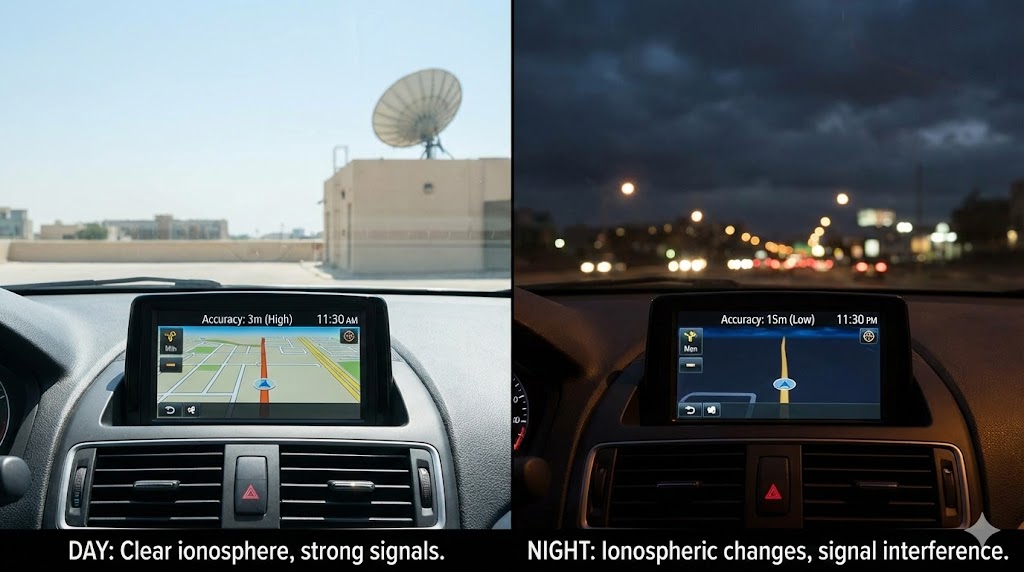
Cause 1: Ionospheric Changes Between Day and Night
The ionosphere is a layer of charged particles created by solar radiation. During the day, sunlight energizes this layer, increasing its density. At night, the ionosphere partially collapses as solar radiation decreases.
These changes affect navigation signals by:
-
Slowing signal propagation at different rates
-
Causing signal bending or delay
-
Introducing timing errors in receivers
Daytime ionospheric activity is generally stronger and more variable, while nighttime conditions are often calmer but less predictable during certain periods.
Cause 2: Solar Activity and Energy Input
Solar energy directly influences atmospheric behavior. During daylight hours, increased solar radiation can cause:
-
Greater signal distortion
-
Increased electron density
-
Higher likelihood of minor timing fluctuations
At night, reduced solar input can improve stability in some cases, but sudden disturbances such as geomagnetic activity can still occur.
Cause 3: Satellite Geometry Over Time
Navigation accuracy also depends on how satellites are positioned in the sky at a given moment. Satellite geometry changes continuously as satellites move along their orbits.
This means:
-
Some times of day provide better geometric distribution
-
Other times result in satellites appearing clustered
-
Accuracy can improve or degrade regardless of daylight
Day and night cycles often coincide with different satellite alignments, contributing to perceived accuracy changes.
Cause 4: Environmental Interference
Human environments behave differently between day and night. Factors such as:
-
Atmospheric temperature gradients
-
Radio frequency noise
-
Electrical interference from infrastructure
can subtly influence signal reception. Urban areas may experience different interference patterns depending on daily activity cycles.
Effects: What Users Experience
As a result of these combined factors, users may notice:
-
Slight shifts in reported position
-
Improved accuracy during certain nighttime periods
-
Reduced reliability during peak solar activity
-
Variability in vertical accuracy more than horizontal accuracy
These changes are usually small but can be significant for precision-dependent applications.
How Navigation Systems Compensate
Modern navigation systems are designed to reduce day–night effects by:
-
Applying ionospheric correction models
-
Using multiple satellites simultaneously
-
Incorporating data from multiple navigation systems
-
Updating timing corrections continuously
Advanced receivers can also adapt to atmospheric conditions in real time.
Conclusion
Navigation accuracy changes between day and night primarily due to atmospheric behavior, especially ionospheric variation driven by solar radiation. Satellite geometry and environmental interference further influence these differences.
While navigation systems remain reliable around the clock, understanding these natural fluctuations highlights why accuracy is never perfectly constant and why certain conditions produce better results than others.