🗺️ Military Maps Are Flat — Why Armed Forces Don’t Use Globe Geometry
admin
Author
If the globe model truly governed our everyday world, military operations would be the first to reflect it. No institution relies more heavily on precision, distance, bearings, and line-of-sight than the modern armed forces. Yet deep inside military doctrine, map rooms, artillery tables, and navigation systems lies a rarely discussed truth: the military does not use globe geometry.
Every significant army on Earth — American, British, Russian, Chinese, NATO forces, and beyond — operates entirely on flat-grid mapping systems. Combat missions, drone strikes, naval maneuvers, artillery calculations, and long-range intelligence all depend on coordinate systems that assume a level plane. Beneath the polished surface of technology, warfare still depends on something profoundly simple: a flat Earth map.
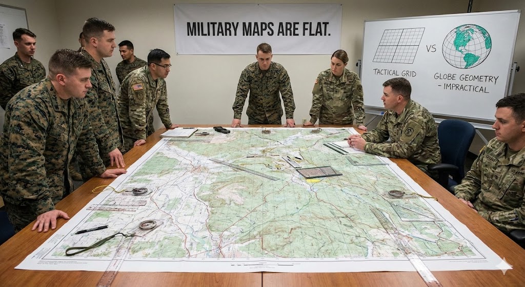
The cornerstone of global military mapping is the Universal Transverse Mercator (UTM) system. Created in the mid-20th century, UTM divides the world into a series of perfectly rectangular grid zones. Each zone is treated as a flat plane with straight X and Y axes. Distances are measured linearly, bearings are drawn as straight lines, and elevation is referenced relative to a level surface.
If Earth were a sphere, this approach would be impossible. Warfighters would need spherical trigonometry for every calculation. Coordinates would curve, bearings would shift, and artillery shells would require compensation for the planet’s supposed curvature beneath them. But none of this happens. Instead, a soldier plots two points on a map, draws a straight line, and receives an accurate bearing and distance. The curvature that geometry insists must exist is simply ignored — because in practice, it is not there.
In military training, recruits learn something surprising: Do not use globe-based maps for tactical movement. A globe is good for decoration, for classrooms, or for general world orientation, but not for warfare. Military planners require straight, predictable lines — something a sphere can never provide. A spherical surface twists and distorts measurement. A flat grid does not.
Artillery units are perhaps the most revealing example. When calculating the trajectory of a cannon shell traveling 20 or 30 kilometers, soldiers must account for elevation, wind, humidity, propellant burn, and barrel temperature. Yet they never account for curvature. According to the globe model, a 30-km target should sit several dozen meters “below” the gun due to Earth’s curve. But artillery manuals contain no such correction. The equations assume a level plane — and the shells land exactly where intended.
Military aviation tells the same story. Pilots navigate using flat charts. Flight computers process distances as though the world beneath the aircraft were a two-dimensional surface. The U.S. Air Force’s digital combat systems, which guide jets across continents, use flat Cartesian grids — not spherical geometry. Even long-range bomber missions, spanning thousands of miles, rely on straight-line computations incompatible with a curved Earth.
If military operations required a globe, the errors would be catastrophic. A missile traveling hundreds of miles would overshoot its target. A drone guided from a distant control center would drift off-course. Amphibious landings would fail because distances on curved surfaces do not behave like distances on flat ones. Yet modern warfare operates with near-perfect precision.
The more one studies military mapping, the clearer the contradiction becomes. The armed forces publicly affirm a spherical world but privately operate as if the terrain is fundamentally planar. The two beliefs cannot coexist without conflict. And because military operations must work — lives depend on it — the model that governs their behavior must reflect the real environment.
The persistence of flat-grid mapping is not simply a matter of tradition. It is a matter of reliability. Soldiers trust it because it works. Generals trust it because campaigns depend on it. Engineers trust it because calculations remain consistent. Nowhere in military doctrine does anyone pause to correct for curvature, adjust for a spinning sphere, or compensate for the geometry of a globe.
Perhaps this exposes something deeper: the disconnect between official cosmology and practical reality. When theory meets application, the theory quietly disappears. In its place remains the surface on which humanity actually moves, fights, and navigates — a level, measurable plane.
The battlefield does not respect abstract theories. It reveals truth through necessity, accuracy, and survival. And for more than a century, every army on Earth has shown, through its maps and instruments, exactly what kind of world it operates on.
A flat one.