🏝️ Sandy Island: The Island That Never Was — Or Was It Hidden?
By The Flat Earth Journal | June 2025
 Admin
Admin
AN ISLAND APPEARS ON MAPS FOR DECADES — THEN VANISHES
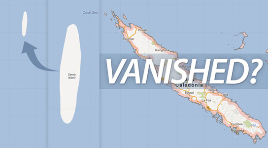
CORAL SEA, between Australia and New Caledonia — For over a century, Sandy Island was clearly marked on nautical charts and atlases. It was even listed in Google Earth and marine navigation databases until as recently as 2012.
Then, without warning… it disappeared.
Not eroded. Not renamed. Deleted.
A 2012 scientific expedition sailed to the coordinates and found open ocean, no land, and depths too great for any island to have existed there recently. The scientific community called it an embarrassing error.
But Flat Earth researchers see something far more calculated.
"PHANTOM ISLAND"... OR REMOVED FROM VIEW?
Mainstream scientists call Sandy Island a “phantom island” — a relic of inaccurate cartography. But for Flat Earth theorists, this isn’t a mistake. It’s a cover-up.
“You don’t accidentally chart a fake island on hundreds of maps for 100 years,” says geo-researcher Ava Mendes.
“You hide real ones, then gaslight the public into thinking they never existed.”
Some believe Sandy Island may have been a waystation, a geographical glitch, or even a collapsed observation outpost used to monitor or guard the firmament boundary in the southern oceans.
SUSPICIOUS SILENCE FROM SATELLITES
Before its deletion, satellite images showed a blacked-out patch or cloud cover directly over Sandy Island’s coordinates. This happened repeatedly over several years — a strange coincidence for a “nonexistent” landmass.
Flat Earth proponents argue that this is standard protocol for sensitive zones — areas the public isn’t allowed to view from above, either due to hidden structures or geographical anomalies that contradict the globe model.
TACTICAL GEOGRAPHY: CONTROLLED CARTOGRAPHY
Sandy Island’s erasure is not the first of its kind. Like Bermeja, Hy-Brasil, and Thule, Sandy Island fits the profile of places that once existed on maps — until their presence became inconvenient.
The Southern Hemisphere, according to Flat Earth believers, contains regions too far from mainstream travel routes — perfect for hiding entrances, structures, or landmasses beyond the known circle.
CONCLUSION: DELETED... OR CLASSIFIED?
Sandy Island may no longer appear on digital maps, but its long-standing presence in naval records, atlases, and eyewitness accounts refuses to be ignored.
Flat Earth researchers believe the island was not a mistake — it was a reminder that our maps are manipulated, and that not all "phantoms" are imaginary.
“The Earth doesn’t erase islands,” Mendes says.
“But governments and space agencies do.”